


RF Planner
توضیحات RF Planner
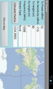
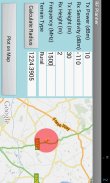
This is a simple application which can be used to do RF planning of a GSM, WCDMA, LTE or WiMAX site. The input parameters are the Tx Power, Rx Sensitivity, Tx Height, Rx Height and Frequency of operation. The output parameter is the Cell Radius which is used to plot the coverage area of the cell site on Google Maps. The coverage scenario can be selected from the following three options:
1. Urban
2. Suburban
3. Rural
The underlying model is applicable to Frequencies of up to 3500 MHz, Distances of 100-8000 m, BS Antenna Heights of 10-80 m and MS Antenna Height of 2-10 m.</div> <div jsname="WJz9Hc" style="display:none">Dit is een eenvoudige applicatie die kan worden gebruikt voor RF planning van een GSM, WCDMA, LTE of WiMAX plaats doen. De input parameters zijn de Tx Power, Rx Gevoeligheid, Tx Hoogte, Rx hoogte en frequentie van de exploitatie. De parameter output is de celstraal die wordt gebruikt om het dekkingsgebied van het celstation Google Maps plotten. De dekking scenario kan worden gekozen uit de volgende drie mogelijkheden:
1. Stedelijke
2. Suburban
3. Rural
Het onderliggende model geldt voor frequenties tot 3500 MHz, afstanden van 100-8000 m, BS antennehoogte van 10-80 m en MS antennehoogte van 2-10 m.</div> <div class="show-more-end">
RF Planner - نسخه 1.0
(13-06-2016)RF Planner - اطلاعات APK
نسخه APK: 1.0حزمة: com.raymaps.rf.planner1آخرین نسخه RF Planner


اپلیکیشنها در دسته مشابه


شاید دوست داشته باشید...


